Article 16 — Overlay Zoning District Regulations
Highway 92 Village Ordinance
Legislative Purpose
Legislative Objectives
B The Village District calls for a pattern of commercial / industrial buildings constructed in the eighteenth and nineteenth century architectural styles. The regulations recognize and are intended to protect and preserve the established residential areas located to the north and south of the improved road. The incorporation of buffering techniques seeks to assist in the preservation of adjoining residential areas by providing a unique transition zone rather than the traditional descending density theory.
C The Highway 92 Village Ordinance is intended to generate quality development along the expanded Highway 92 thoroughfare while promoting economic, cultural, open space, and safety features to promote the public welfare. This orderly planning system is intended to attract quality development.
Boundaries
B Map
Prohibited Uses within the Highway 92 Village Ordinance:
The following uses shall be prohibited within the Highway 92 Overlay District:
NAICS Code NAICS Description 423140 Motor Vehicle Parts (Used) Merchant Wholesalers 441110 New Car & Light Truck Dealers 441120 Used Car & Light Truck Dealers 441210 Recreational Vehicle Dealers 441222 Boat dealers, new and used 441228 Motorcycle, ATV, and All Other Motor Vehicle Dealers 443142 Electronics Stores (Adult video shops only)
453930 Manufactured (Mobile) Home Dealers 484110 General Freight Trucking, Local 484121 General Freight Trucking, Long-Distance, Truckload (TL)
484122 General Freight Trucking, Long-Distance, Less Than Truckload (LTL)
484220 Specialized Freight (except Used Goods) Trucking, Local 484230 Specialized Freight (except Used Goods) Trucking, Long-Distance 454390 Other Direct Selling Establishments (Itinerant Merchants, i.e. temporary stands only)
522291 Consumer Lending (Short-Term Loans only)
522298 All Other Nondepository Credit Intermediation (Pawn Shops only)
522390 Other Activities Related to Credit Intermediation (Check Cashing & Payday Lending only)
531130 Lessors of Miniwarehouses and Self-Storage Units 713990 All Other Amusement and Recreation Industries (Pool Halls & Billiard Parlors only)
811111 General Automotive Repair 811121 Automotive Body, Paint, and Interior Repair and Maintenance 811198 All Other Automotive Repair and Maintenance Nude/Semi-Clothed Dancing Establishments
Development Regulations for the Corridor
1 Streetscape a Front yard areas shall contain landscaping at least forty (40) feet in depth along all Highway 92 and intersecting cross street frontages except where driveways may be required. The streetscape depth shall be measured from the outside edge of the sidewalk within the right-of-way.
b A three rail fence of appropriate style, white in color, shall be required within 2’
feet of the right-of-way of Highway 92.
c An overstory tree not less than 3” DBH as indicated in the Tree Ordinance shall be planted every 40 feet on center along the entire roadway frontage of the property within the landscape strip.
d A landscaped berm of no less than three (3) feet in height or evergreen landscape planting no less than three (3) feet in height at the time of planting shall be provided to screen vehicular parking areas, loading areas, and dumpsters from view from Highway 92.
e The streetscape shall consist of fences, berms, connecting sidewalks, trees, and other plantings.
f Existing (undisturbed) landforms, trees, and other elements such as berms planted with a range of native plant species shall be provided within landscape areas.
2 Utilities All site utilities shall be located underground.
3 Architecture a Buildings shall be designed to substantially resemble eighteenth and nineteenth century styles.
The following examples illustrate Cherokee County buildings from this time period:
b Building mass shall be broken up to give the appearance of individual buildings or places of business, presenting a village appearance c Large areas of uninterrupted brickwork shall be broken up through the use of trellises, arcades, blind windows, archways, or other patterns.
d Window areas shall not extend down to the floor line. A wall of not less than 2’
in height shall separate the floor from the bottom of the window frame.
4 Building Materials a Buildings shall have no less than 80% of the non-glass area of three exterior sides faced with natural-colored brick or stone that simulates historic types of masonry.
b Multi-pane windows shall be used in individual window openings, rather than large glass sheets.
c Mirrored glass with a reflection greater than twenty (20) percent and glass curtain walls are prohibited.
d Paint colors shall be of traditional, historic types which are generally muted tones such as ivory, cream, beige, white, and pastel colors. Colors which are not permitted are bright or vibrant colors of purple, green, orange, pink, or violet, which are considered inconsistent with the district.
5 Roof Lines a Any building with a pitched roof shall have a minimum pitch of four (4) inches vertical elevation per one (1) foot of horizontal distance.
b Buildings without pitched roofs shall have detailed parapets and cornices, in keeping with eighteenth and nineteenth century architectural styles.
c All roofing materials shall be of a consistent style and pattern. Pitched roofs shall be finished in either architectural or dimensional shingles, or standing seam metal roofs.
6 Signage a Freestanding Signs i All freestanding signs shall be of a monument style and constructed only of brick or stone materials to match or compliment the principal structure or structures located on the site.
ii The maximum copy area shall be 50 square feet with a maximum sign height of 10 feet.
iii If the sign lists multiple tenants the sign shall be of a uniform background lettering style and color.
b Wall Signs i Illuminated wall signs shall be channel-type letters only and shall be established in a such a way that no light is cast upon adjacent properties and roadways.
ii All wall signs shall be common colors such as red, yellow, green, blue, brown, white, black, or pink. Colors that are not allowed are bright or vibrant colors of purple, green, orange, pink or violet.
iii Specific dimensional requirements for all wall signage are governed by the Sign Ordinance of Cherokee County, Georgia.
c See Article 11, Section 11.8 Prohibited Signs for a complete list of prohibited signs.
7 Traffic Access Requirements Access to Highway 92 must comply with all County and State requirements. Internal roadways or vehicular connections making developments accessible to each other shall be used whenever possible to discourage traffic congestion on Highway 92.
8 Parking Each development shall provide not less than two (2) nor more than four (4) parking spaces per 1000 square feet of gross building floor area for all uses except residential development. Parking for residential development shall follow Article 12
9 Undisturbed Buffers The intent of buffers is to provide a year-round visual screen between dissimilar land uses. Undisturbed buffers shall be required per Article 10 of the Zoning
Implementation
It is the desire of the County, its citizens and private property owners cooperating in the creation and adoption of this Ordinance to implement it as rapidly as possible and to do so in a fair manner. Existing conditions need not change immediately upon the adoption of this Ordinance.
After the adoption by the Board of Commissioners, the Ordinance will apply to all new development plans/new construction plans submitted after the effective date of this Ordinance adoption. The exterior renovations to a building must comply with the Ordinance requirements. The structural aspects of this Ordinance will not be triggered by standard maintenance activities not requiring a building permit.
Variances
Severability
Relationship to Industrial Land Uses
Bells Ferry Community Design District
Purpose and Intent
Boundaries
The Bells Ferry Community Design District shall apply to all properties within the geographic boundaries shown on the Bells Ferry Regulating Plan. The District is intended to supplement existing zoning regulations. The Bells Ferry Regulating Plan is shown as Figure 16.2.
Incorporation by Reference
District Conditions
1 The development of property within the Bells Ferry Community Design District shall comply with the Minimum Standards set forth herein.
2 Any non-residential structure that is built prior to the adoption of this ordinance will not have to adhere to the Design guidelines set forth within this document.
3 Whenever the requirements of the District impose a more or less restrictive standard than the provisions of any other statute or covenant, the requirements of the District shall govern.
Specifically, where the Hwy. 92 Village Overlay intersects the Bells Ferry Community Design District, the Bells Ferry Community Design District regulations outlined herein shall apply.
4 The Design Guidelines of this document shall not change any of the existing zoning for the land that lie within the boundaries of this overlay district.
5 At no time shall the District regulations preclude a property owners ability to seek a change in zoning of their property within the district.
B Development Alternatives.
1 Property within the District boundaries may be developed per an approved Neighborhood Plan without the need to seek a change in zoning. The Neighborhood Plan must comply with all of the Bells Ferry Community Design Guidelines, including the Minimum Standards.
2 Alternatively, if the property owner chooses to develop the property under the existing zoning, only the Minimum Standards must be adhered to and compliance demonstrated through an approved development plan.
Regulating Plan
The Neighborhood Zones represent different human environments which contain elements forming its built condition like streets, buildings, landscaping, etc. or what is termed a “form based” code. Each zone is differentiated by the combination of elements comprising the Neighborhood Zone. For instance, a Residential Street is less urban than a Boulevard. A four story building is more urban than a single family house with a front yard and a porch.
The Regulating Plan is the basis for directing and guiding future development within the Corridor.
Minimum Standards
Development under existing zoning shall include land uses permitted by Article 7 – District Uses and Regulations of the Cherokee County Zoning Ordinance.
B Street Network.
Plans for development shall include the following transportation elements of the Bells Ferry Community Design Guidelines:
1 Provisions for Proposed Primary Roads and Bells Ferry Parkway. (see Street Network, page 14)
2 Provisions for Pedestrian & Bicycle Facilities. (see page 16 )
3 Interparcel Access -Interparcel vehicle access points between all contiguous parcels must be provided to allow opportunities for future development to connect in and improve network connectivity.
C Streetscape Requirements.
All development shall comply with Streetscapes defined in the Bells Ferry Community Design Guidelines for State Route 92 (Bells Ferry Community Design Guidelines, page 27), Bells Ferry Road (Bells Ferry Community Design Guidelines, page 28) and Bells Ferry Parkway (Bells Ferry Community Design Guidelines, page 26). This includes frontage requirements also identified on the Regulating Plan.
D Pedestrian Facilities / Frontage Requirements All development shall comply with the design requirements for Pedestrian Facilities / Public Frontages as defined in the Bells Ferry Community Design Guidelines (see page 30 and 31)
E Building Frontage / Private Frontage Requirements All development shall comply with the design requirements for Building Frontage / Private Frontage as defined in the Bells Ferry Community Design Guidelines (see page 32 and 33)
F Architectural Controls.
All development shall comply with Façade Materials, Doors & Windows and Roofs defined in the Bells Ferry Community Design Guidelines (see pages 34-36)
G Signage.
All development shall comply with Signage defined in the Bells Ferry Community Design Guidelines (see page 40).
Design Guidelines
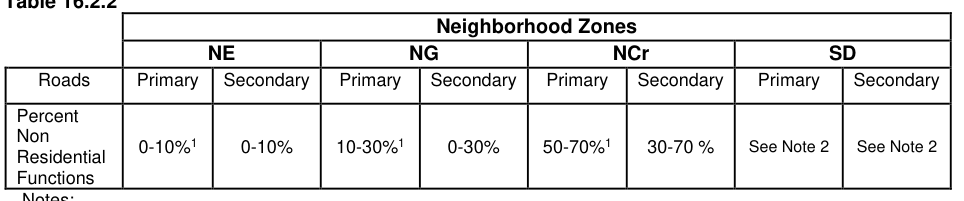
All development under the Design Guidelines shall be subject to the use limitations set forth in Article 8 Traditional Neighborhood Development, Table 10 - Specific Functions.

Table shall govern the percentage of Non-Residential Functions required under the Bells Ferry Design Guidelines. Parcels of land meeting both of the following requirements shall be subject to the Primary road percentages:
1 All parcels with any part of the parcel within 400 feet of an existing or proposed Primary road as shown on the Street Network Plan.
2 Parcels of 3 acres or more in size.
All other parcels will be subject to the Non-Residential Functions percentages for Secondary roads.
Where a tract of land within the Bells Ferry Community Design District is 3 acres or less and is unfeasible for development as a mixed use project in accordance with this ordinance, and is not likely to be assembled into a larger plan of common development, the property owner may propose to develop such property as a single use project under the provisions outlined below:
1 Single Use residential may be proposed at no more Base Building Units than allowed under the guidelines for Neighborhood Edge (NE) as outlined herein, unless a warranted variance is issued under section 8.19 of Article 8 Traditional Neighborhood Development. A warrant may be issued only if evidence can be presented by the property owner that one or more of the following conditions exist:
a The subject property cannot physically be accessed by adjacent property;
b The subject property cannot feasibly be assembled into a larger plan of common development because adjoining property(s) are already developed and the pattern of development on the adjoining property prevents development as a larger plan of common development;
c The subject property is surrounded by properties zoned for or developed above the Base Building Units of the Neighborhood Edge (NE);
d Development of the subject property above the Base Building Units of the NE would be an addition to the area and would not be a detriment to the surrounding development pattern 2 Single Use non-residential projects must follow the Minimum Standards as outlined herein.
Neighborhood Plans
a Configuration of Neighborhood Zones (based on Bells Ferry Regulating Plan)
b Planned Street types and street configuration c Location of Civic Building sites and Civic Spaces d Frontage Characteristics of Streets 2 Illustrative Plan (Building Scale Plan)
a Building Disposition (lots and building footprint)
b Configuration (frontages and building heights)
c Building function and density d Parking standards 3 Community Standards a Covenants for Governance b Architectural Standards c Environmental Standards d Landscape Standards e - Including a tree plan meeting the requirements of Article 25 - Tree Preservation and Replacement Ordinance f Signage g Ambient (lighting and sound)
h Visitibility B Plans Review Process Each Neighborhood Plan shall respond to the existing conditions of the site, adjacent developments, connecting thoroughfares, natural features and man-made traces.
Tree Preservation and Replacement Alternate Plan
B Intent. The intent of providing this alternative is to consider a proposal that balances effective tree preservation and replacement with the requirements presented within the Bells Ferry Community Design District.
C Alternate Plan. The Alternate Plan shall include the following:
1 A plan prepared by a qualified design professional according to standards outlined in Article 27, providing for tree preservation and replacement, indicating any areas challenged by design, physical constraints, or similar hardship factors.
2 Details and any supporting information addressing the following Board of Commissioner review criteria factors under Section 16.2.9 (D).
D Alternate Plan Review. Notwithstanding any other provisions to the contrary contained in the Code of Ordinances, Cherokee County, Georgia and in the 1992 Zoning Ordinance of Cherokee County, the Board of Commissioners shall review an Alternate Plan considering any of the following factors:
1 Challenges of upgrading the infrastructure of previously-developed property to accommodate development envisioned by the Bells Ferry LCI Plan.
2 Presence of existing structures, utilities or paved areas to be demolished and/or removed.
3 Constraints created by the urban design and public realm elements required to develop in accordance with the District that may present challenges to meeting tree density requirements.
4 Whether an Alternate Plan demonstrates sufficient overall tree density with a clear effort made to maximize tree preservation in natural areas and tree recompense wherever complementary to the design of the project.
5 Additional site improvements, which could include the installation of additional landscaping materials, construction of public improvements, right-of-way and easement dedications for public improvements, donation of trees and landscaping materials for public parks, donation to the tree fund, provision of a benefit to the general public (pavilion, playground, public art, etc., provided beyond restricted-access amenities), or other proposed enhancements, or a combination of improvements.
6 Any other factors or extenuating circumstances that may warrant the approval or denial of an Alternate Plan.
E Alternate Plan Decision. The decision to approve or deny an Alternate Plan is at the discretion of the Board of Commissioners. An alternate plan proposal may be placed on any regular meeting agenda of the Board of Commissioners for a decision. A public hearing may be required by or waived at the discretion of the Board of Commissioners.
Highway 20 East Overlay District
Statement of Significance
Intent
Boundaries
Development Size
Site Design Standards
Streetscape Cross View
Streetscape Diagram
inches on center. Fence materials shall be comprised of treated lumber, fiber cement, or steel.
Leyland Cypress Cupressocyparis leylandii PEST PRONE PLANT MATERIALS TREES Canadian Hemlock Green Ash Tsuga canadensis Fraxinus pennsylvanica
Architectural Standards
Architectural elements include but are not limited to awnings/canopies, shutters, window/door detailing, trellises, brackets, or dormers.
A minimum of 10% of the wall face along a side street shall contain windows or doorways.
Relationship to Adaptive Reuse
Use Restrictions
If at least fifty (50%) or more of the site or building is screened by other buildings or vegetation from view of public rights-of-way, then the building may utilize textured concrete block, split faced concrete block, or metal wall panels on the side and rear of the building. Additionally, three stories shall be allowed. Measurement shall be from grade (or crown of the road) to the ridge (pitched roof) or parapet (flat roof).